 |
||||||
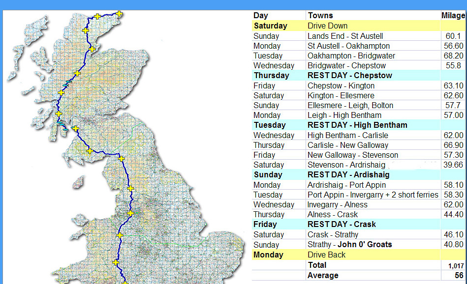
Route Map :-
 |
||
 |
||
 |
||
The Route The starting point for the route was from a website where four guys had done the trip on road bikes with minimal luggage. They stayed at youth hostels and averaged between 60 and 80 miles a day. I was adamant that I didn’t want to do any more than 60 miles a day and I certainly didn’t want to stay at youth hostels, but that was the starting point and I’m certainly very grateful to those guys for providing such an excellent site to help me with my trip. Each day the guys did a diary saying what the route was like and explaining the bits that they liked and didn’t like. I used that information and routed round all the bits which were problematic such as trails with inadequate surfaces for road tyres, hills which were too steep to climb, main roads that were heavy with traffic and generally all the bits they didn’t like. The Planning I purchased memory maps for all the regions that I was routing through. These consisted of Southern England, Central England, Northern England, Southern Scotland and Northern Scotland. The maps are ordinance survey maps scale OS 1:50k and you plan your route by clicking along the roads you want to use. You have to remember not to use more than 250 way points for each route otherwise you can’t transfer them to a Garmin GPS unit for use on the bike. I bought a Garmin GPS 60CSX which will take four routes at a time and also took with me a Garmin GPS 60 as a spare that will hold two routes. The Garmin GPS 60 was the unit I had been using in planning my training routes, so I was very comfortable with its accuracy and quirks and knew that I wouldn’t need to take any maps with me. In all there was a total of 18 routes, the longest being 68 miles and the shortest ones 40 miles. I purchased a Toshiba net book to take with me to store all the routes and to enable me to closely study the next days route and to monitor any wrong turns I had made. This is easily done at the end of each ride by importing the days track and comparing it with the intended days route. If there were any problems I would then be able to modify the route to make it a little easier for any one else wishing to follow. The Back Up Plan I knew that I had safely loaded the first six routes on the two garmins I was taking with me. That would take me well up country to Ellesmere. If the lap top failed on route with bumping over potholes on the downhill sections then Ali, my wife, was asked to volunteer to join me there with her lap top, on which we’d also loaded the maps and all the routes. She would also purchase a new garmin 60CSX, and a spare garmin 60 borrowed from a friend. I would then be able to load up the twelve remaining routes to get me to John o' Groats and would be able to ditch my own net book to reduce weight |
copyright Dick Glaves © 2009